
How Real Time GPS Tracking Works
Real-time GPS tracking shows you a live, moving position on an interactive map rather than storing location data for later download. Unlike passive trackers that simply log coordinates until you physically retrieve them, active trackers transmit data continuously over a cellular network or satellite connection letting you see exactly where a vehicle or asset is at any given moment, second by second or at set intervals.
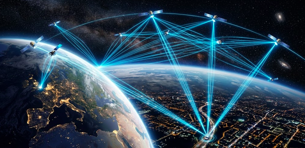
Real-time GPS tracking refers to the continuous transmission of location data from a GPS-enabled device to a centralized software platform. The global positioning system became fully operational in the mid-1990s. Today, around 31 GPS satellites circle Earth while billions of devices rely on this GPS tracking technology daily from smartphones to fleet vehicles to wearable trackers for children and elderly relatives.
Whether you are a fleet manager monitoring vehicles across multiple states, a parent wanting peace of mind about a teen driver, or a business protecting valuable assets, understanding how these tracking systems function helps you make smarter decisions about reliability and accuracy.
Key components of real-time GPS tracking:
-
Satellites broadcasting precise time and position signals
-
A GPS receiver in the tracking device
-
Communication networks (cellular or satellite)
-
Cloud servers processing location data
-
Apps and dashboards displaying real time location data
Quick Answer: How Real-Time GPS Tracking Works
Here’s the short version of how a real time GPS tracker works before we get into the details:
-
Satellites broadcast signals: GPS satellites continuously send radio signals containing their exact position and timestamp
-
Your GPS device listens: GPS receiver chip calculates its three dimensional position by measuring distances to at least four satellites
-
The tracker transmits: The device packages this location along with speed and heading, then sends the data over cellular or satellite networks
-
Servers process updates: A central server receives position fixes every 10-60 seconds, stores them, and checks for geofence violations or speed alerts
-
You see live movement: Web dashboards and mobile apps display the exact location as a moving icon on a map
The Building Blocks of GPS Tracking Systems
Modern GPS tracking systems rely on global navigation satellite systems (GNSS), which include not just American GPS but also Russia's GLONASS, Europe's Galileo, and China's BeiDou. Together, these satellite networks provide redundancy and better worldwide coverage. GPS technology utilizes 24 to 32 solar-powered satellites and ground stations to transmit information to GPS-enabled devices.
A typical real-time solution has four interconnected pieces:
-
Space segment: Satellites broadcasting navigation signals.
-
Control segment: Ground stations that monitor and correct satellite data. Monitoring stations on Earth track satellite health and orbits, uploading corrections to keep data accurate.
-
User segment: GPS tracking devices, smartphones, and vehicle receivers
-
Communication networks: Data transmission networks like cellular networks, 4G/5G, or satellite networks send location data to a central server for real-time monitoring.
The Space Segment: GPS and Other GNSS Satellites
U.S. GPS constellation maintains approximately 24 core satellites plus several spares around 30-31 active at any time orbiting at about 20,200 kilometers altitude in medium Earth orbit. Each satellite completes two orbits per day, ensuring that 4-8 satellites are visible from most locations under open sky.
Other global navigation satellite systems add even more coverage:
-
GLONASS : 24 satellites in similar orbits
-
Galileo : 30 planned satellites with advanced civilian signals
-
BeiDou : 35 satellites providing global coverage since 2020
Modern GPS tracking devices can use multiple constellations simultaneously, dramatically improving reliability and reducing the time needed to determine location when first powered on. Multi-constellation support means your tracker can lock onto 50+ satellites for improved performance in cities and remote areas.
What Satellites Transmit to Your Tracker
Each satellite broadcasts low-power radio signals on specific L-band frequencies (primarily 1,575.42 MHz for civilian use). GPS signals travel at the speed of light approximately 299,792 kilometres per second which is crucial for calculating distances in real-time GPS tracking. These satellite signals contain:
-
The satellite's unique identification code
-
Precise transmission timestamp from onboard atomic clocks
-
Orbital parameters describing current position
-
Almanac data for the entire constellation
The GPS receiver never sends data back to satellites it only listens. Because signals travel at the speed of light, even a billionth-of-a-second timing error translates to roughly 30 centimetres of position error. This is why satellite navigation depends on extraordinarily precise atomic clocks accurate to one second in 30 million years.
The Control Segment: Ground Stations and System Management
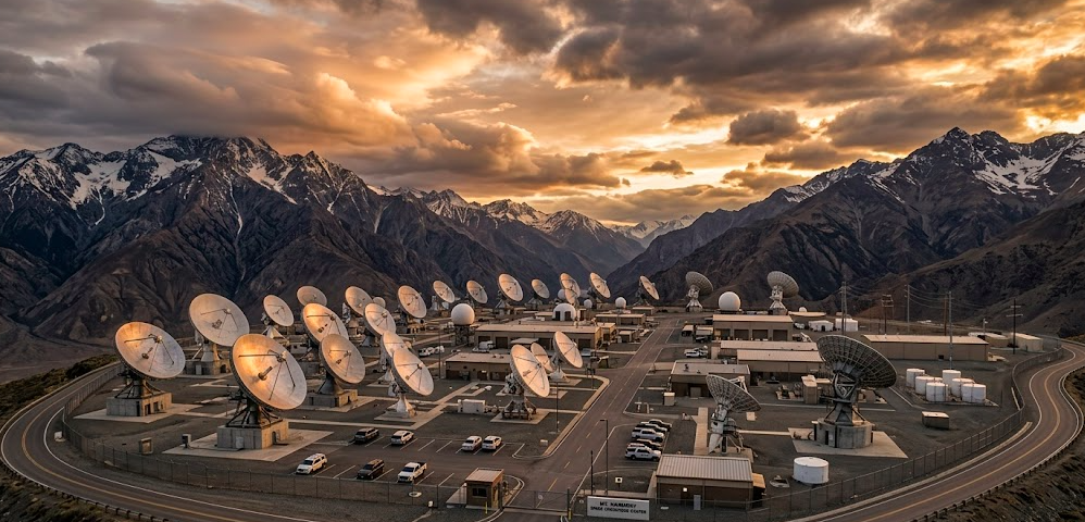
Behind every reliable GPS fix is an invisible network of ground stations continuously monitoring satellite health. Most people never think about this layer but without it, your GPS tracker would drift off by kilometres within hours.
The control segment has three main parts working together around the clock:
-
Monitor stations are placed around the world from Colorado Springs to Hawaii to Ascension Island. Their job is simple: listen. They track signals from every satellite passing overhead and record tiny timing shifts and orbital changes that would otherwise go unnoticed.
-
The master control station at Schriever Space Force Base in Colorado acts as the brain. It collects data from all monitor stations and calculates how much each satellite has drifted. Even atomic clocks lose accuracy over time, and without correction, errors can grow by up to 10 kilometres per day.
-
Ground antennas handle the final step. They send updated corrections back to the satellites several times a day. This keeps satellite position and timing accurate within a few metres the level your GPS device needs to work properly.
A simple way to look at it: satellites send signals, your GPS device receives them, and the control segment fixes the errors in between. Without these constant corrections, location data would quickly become unreliable. For anything that depends on accuracy fleet tracking, safety monitoring, or asset protection that simply wouldn’t work.
The User Segment: GPS Trackers, Phones, and Onboard Receivers
Any real-time tracking device contains at least three core components:
-
GNSS receiver chip: Processes satellite signals to calculate position.
-
Processor: Runs firmware, manages sensors, and packages data.
-
Communication module: Typically a cellular modem with SIM card, or satellite transceiver.
Common device types include smartphone GPS chips, OBD-II plug-in vehicle trackers, hardwired fleet units, and pocket-size personal trackers with batteries lasting 3-5 years on infrequent reporting schedules. Wearable trackers also allow families to monitor children or elderly relatives, enhancing personal safety.
GPS receivers can achieve accuracy within 5 metres to less than a millimetre, depending on the device quality and technology used. Most consumer GPS tracking devices achieve 3-5 metres accuracy in open sky, while survey-grade equipment using advanced corrections reaches centimetre-level precision.
How the Receiver Calculates Position (Trilateration)
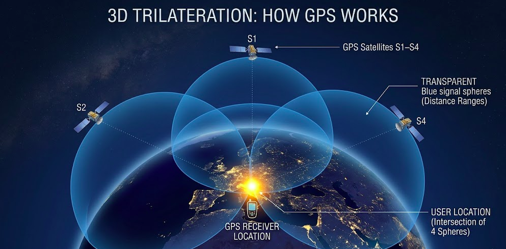
GPS tracking systems require signals from at least four satellites to calculate precise locations using a method called trilateration not triangulation. Here is the difference: triangulation uses angles, while trilateration uses distances.
The process works like this:
-
The receiver compares each satellite's transmitted timestamp against its own clock.
-
It calculates how long the signal travelled and multiplies by the speed of light to estimate distance.
-
Each distance creates an imaginary sphere around that satellite.
-
With measurements from at least four satellites, the receiver finds the single point where all spheres intersect.
Why four satellites instead of three? Three satellites give you a three-dimensional position, but a fourth is needed to correct for timing errors in the receiver's less-precise quartz clock. This mathematical solution happens in milliseconds, giving you an exact position ready for transmission.
From Position to Real Time: How Data Flows to Your Screen
Once your GPS device calculates its position, the real-time magic happens through constant communication with cloud infrastructure:
-
On-device processing: The tracker combines GPS coordinates with speed, heading, and sensor data into a compact packet (often under 1 KB).
-
Network transmission: A cellular modem (4G LTE, LTE-M, or legacy 2G/3G) sends data to a central server every 10-60 seconds.
-
Server processing: The server authenticates the device, logs timestamped points, and runs checks for geofence violations, speed alerts, or unauthorised movement.
-
User interface: APIs push updates to web dashboards and mobile apps, displaying mobile assets as animated icons on an interactive map.
Real-time tracking allows users to monitor movements as they happen second by second or at set intervals unlike passive systems that store data for later retrieval. Modern GPS tracking systems often include features like instant alerts for movement, speeding, or geofence violations, all displayed on an interactive map.
Cellular vs. Satellite Communication in Real-Time Tracking
|
Feature |
Cellular Trackers |
Satellite Trackers |
|---|---|---|
|
Coverage |
Urban/suburban areas with cellular coverage |
Near-global, including oceans and remote regions |
|
Monthly cost |
$5-20 per device |
$25-100+ per device |
|
Data speed |
High (supports rich sensor data) |
Low (2.4 kbps typical) |
|
Best for |
Fleet vehicles, personal trackers, construction equipment |
Ships, remote mining, aircraft, expeditions |
Hybrid devices can switch between cellular and satellite links automatically, maintaining real time data as assets move through different coverage zones.
What Makes GPS Tracking Accurate (or Inaccurate) in Real Time
Several factors can degrade your tracking accuracy:
-
Signal blockage: Tunnels, parking garages, and dense forests block satellite signals entirely
-
Multipath interference: Urban canyons cause signals to bounce off buildings, making the tracker appear to “jump” a few feet or appear on the wrong street
-
Atmospheric delays: Ionospheric and tropospheric conditions can introduce 5-10 meters of error
-
Poor satellite geometry: When visible satellites cluster in one area of sky, mathematical precision suffers
Update frequency also matters. More frequent updates (every 3 seconds) show smoother movement patterns but drain batteries faster. Most trackers balance this by reporting every 15-60 seconds during motion and less often when stationary.
Technologies and Techniques that Improve Real-Time Accuracy
Several augmentation methods help smarter tracking achieve better precision:
-
WAAS/EGNOS: Wide Area Augmentation System (WAAS) and European Geostationary Navigation Overlay Service (EGNOS) are systems that improve GPS accuracy by correcting signal errors.
They send real-time correction data through satellites, helping GPS devices deliver location accuracy within about 1-2 meters across North America and Europe.
-
Differential GPS (DGPS): Fixed ground stations at known locations send data corrections, achieving sub-meter accuracy
-
Multi-GNSS support: Using GPS, GLONASS, Galileo, and BeiDou simultaneously improves reliability in challenging environments
-
RTK (Real-Time Kinematic): Base stations provide carrier-phase corrections for centimeter-level positioning in precision farming, surveying, and scientific research
How Real-Time GPS Tracking Is Used in Practic
Real-time tracking is used in diverse sectors like fleet management, personal safety, and agriculture for operational efficiency. Real-time GPS tracking allows businesses to provide customers with live updates, estimated arrival times, and proof of delivery, boosting credibility and satisfaction:
-
Fleet management: Dispatchers monitor vehicles in real time, optimize routes, and reduce idle time by 10-20%. Businesses use GPS trackers to monitor driver routes, optimise fuel consumption, and enhance productivity.
-
Logistics and delivery: Accurate ETAs improve customer satisfaction and enable dynamic rerouting around traffic.
-
Construction: Geofencing around job sites triggers alerts for valuable machinery arriving or leaving, reducing theft by 30-50%.
-
Personal safety: Families track teen drivers’ driving habits, check on elderly family members, or locate vulnerable individuals in emergencies, Wearable trackers allow families to monitor children or elderly relatives, enhancing personal safety.
-
Law enforcement: Stolen vehicle recovery rates exceed 90% within hours when vehicles have active trackers
-
Asset protection: With real-time tracking, users can receive instant alerts if a tracker moves outside designated areas, helping prevent theft and unauthorised use.
Business Benefits of Live Tracking Data
Real-time GPS tracking provides instant location updates, operational visibility, and critical data that businesses can use to improve productivity and reduce costs. Organisations using real-time GPS tracking typically see measurable returns:
-
Fuel savings of 15-25% through optimized routing and reduced idling
-
Productivity gains of 10-15% from better dispatching and accountability
-
Reduced theft and faster recovery of stolen vehicles and construction equipment
-
Driver safety improvements by monitoring harsh braking, speeding, and driver behavior patterns
-
Compliance automation with mileage logs, hours-of-service records, and proof-of-delivery documentation
Historical tracks combined with live GPS data enable long-term optimization of routes, staffing, and asset deployment decisions.
Limitations, Privacy Concerns, and Future Trends
Despite its power, GPS tracking works only under certain conditions. Key limitations include:
-
Sky dependency: Indoor environments and tunnels require fallback to cell tower or Wi-Fi positioning
-
Battery constraints: Compact trackers must balance update frequency against battery life - though the Lightning GPS 140-Day Long Life Tracker is built specifically to solve this problem
-
Coverage gaps: Rural areas may lack cellular coverage for data transmission
-
Potential outages: Solar flares and system anomalies occasionally affect accuracy
Privacy requires careful attention. Tracking employees or family members demands transparent policies, proper consent, and compliance with specific laws like GDPR and CCPA. Secure data handling with encryption and clear retention policies (typically 30-90 days) are essential.
Looking ahead, expect these trends by the late 2020s:
GPS technology is moving fast. Over the next few years, it won’t just be about tracking location, it will be about smarter, longer-lasting, and more precise systems that work almost everywhere.
Here’s what to expect:
-
More GNSS satellites: 100+ navigation satellites will be operational globally
-
Longer battery life: Low-power LTE-M and NB-IoT devices could run for up to 10 years without frequent charging
-
AI-powered alerts: Systems will automatically flag unusual routes, unexpected stops, or behavior changes
-
Indoor-outdoor tracking: Integration with UWB and Bluetooth will extend tracking inside warehouses and buildings
Real-time GPS tracking will become more accurate, more intelligent, and more deeply integrated into daily operations. Whether you’re protecting valuable assets, ensuring driver safety, or simply wanting to know where your delivery truck is at any given moment, understanding how GPS works helps you choose solutions that deliver genuine operational visibility and peace of mind.
Conclusion
Real-time GPS tracking brings together satellites, smart devices, and powerful networks to deliver accurate location data exactly when you need it. It goes beyond simply knowing where something was, it gives you live visibility, helping you track movement in real time and make faster, more informed decisions. From precise satellite signals to cloud-based platforms, every component works together to ensure reliable and up-to-date tracking.
For businesses, this means improved efficiency, reduced costs, and better operational control. For individuals, it offers greater safety, peace of mind, and the ability to stay connected to what matters most.
As GPS technology continues to evolve with higher accuracy, longer battery life, and intelligent features like AI-driven alerts, its impact will only grow stronger. Whether you're managing a fleet, protecting valuable assets, or monitoring loved ones, understanding how real-time GPS tracking works helps you choose a solution that truly fits your needs.
If you're ready to experience reliable and advanced GPS tracking, explore professional solutions with a GPS tracker and find the right system for your needs today.
Frequently Asked Questions
How does real-time GPS tracking work?
A GPS tracker receives signals from at least four satellites and uses a process called trilateration to calculate its exact location. It then sends that location along with speed and direction to a central server via a cellular or satellite network. You see the result as a live moving position on a map, updated every few seconds.
What is the difference between real-time and passive GPS tracking?
Real-time GPS tracking transmits location data continuously to a live platform so you can see movements as they happen. Passive tracking stores location data on the device itself, and you can only access it after physically retrieving the tracker and downloading the data.
How accurate is real-time GPS tracking?
Most consumer GPS trackers are accurate within 3-5 metres in open sky conditions. Accuracy can be affected by tall buildings, dense trees, tunnels, and weather.
Advanced systems using Differential GPS or RTK corrections can achieve sub-metre or even centimetre-level accuracy.
How many satellites does GPS tracking need?
A GPS tracker needs signals from at least four satellites to calculate a precise three-dimensional location. The fourth satellite is specifically needed to correct timing errors in the receiver's internal clock.
Does GPS tracking work indoors?
Standard GPS signals struggle indoors because satellite signals cannot easily penetrate roofs and walls. Most modern trackers fall back to cell tower or Wi-Fi positioning indoors, which is less precise but still gives an approximate location.
What is a geofence in GPS tracking?
A geofence is a virtual boundary you set around a specific area on a map. When a tracked vehicle or asset crosses that boundary either entering or leaving the system sends you an instant alert. It is commonly used for job site security, fleet management, and child safety.
Posted by Kellie Kendall on Feb 11th 2026