
How Do GPS Trackers Work? A Complete 2026 Guide
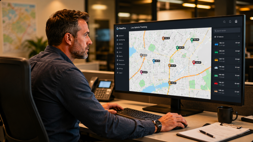
You open an app and see exactly where your teenager's car is right now, down to the street. A fleet manager watches 40 delivery vans move across a live map from a single screen. That level of real-time tracking used to belong to spy movies. Today it fits in your pocket.
But how does GPS tracking actually work? What happens between a satellite thousands of miles above Earth and a dot on your phone? Why do some GPS tracking devices update every five seconds while others run for months on a single charge?
This guide breaks down the entire process from GPS satellites and radio signals to cellular networks, trilateration, and the software platform that turns raw location data into something you can act on. Whether you are buying your first GPS tracker or building a fleet tracking system, you will leave here knowing exactly what to look for.
What Is a GPS Tracker?
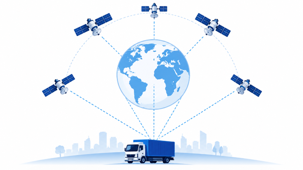
A GPS tracker is a GPS-enabled device that uses the Global Positioning System (GPS), a network of at least 31 U.S. Air Force-operated satellites orbiting about 12,550 miles above Earth, to determine and report its location. These satellites broadcast free radio signals with precise timing and position data.
The GPS receiver in the tracker calculates its location by analyzing signals from multiple satellites. While receiving GPS signals is free, transmitting the location data to your phone or dashboard requires a cellular or satellite modem built into the device, which may involve subscription costs.
How Does GPS Tracking Work? The Science Behind the Signal
Step 1: GPS Satellites Broadcast a Time-Stamped Signal
Every satellite in the GPS satellite constellation continuously broadcasts a radio signal containing two critical pieces of data: the satellite's exact position in orbit and the precise time the signal was sent, measured by an onboard atomic clock accurate to within a billionth of a second.
These signals travel at the speed of light, roughly 186,000 miles per second. Even at that speed, each GPS signal takes a measurable fraction of a second to reach a ground-level GPS receiver.
Step 2: The GPS Receiver Calculates Distance from Each Satellite
The GPS receiver inside your tracker picks up these satellite signals and notes the exact time they arrive. By comparing the signal's send time to its receive time, the device calculates how long the signal traveled.
Since the signal moves at the speed of light, that travel time translates directly into distance. If a GPS signal from a satellite took 0.067 seconds to arrive, that satellite is roughly 12,540 miles away. The receiver repeats this calculation for every visible satellite in the constellation, typically between 6 and 12 at any given moment.
Step 3: Trilateration Determines Location
With one satellite, the GPS receiver knows it is somewhere on a sphere of a certain radius around that satellite. With two satellites, the possibilities narrow to a circle. With three, a specific point on the Earth's surface is identified. With signals from at least four satellites, the standard for modern civilian GPS, the device calculates a precise three-dimensional location: latitude, longitude, and altitude.
This process is called trilateration, not triangulation (which uses angles rather than distances). The more satellites in view, the higher the accuracy of the location data. The U.S. government guarantees GPS accuracy of 2 meters 95% of the time under open-sky conditions. This is the baseline standard built into the civilian GPS signal and modern assisted GPS technology pushes real-world accuracy even further for everyday tracking devices.
From Satellite Signal to Your Screen: How GPS Tracking Works End-to-End
GPS positioning gives you a set of coordinates. Here is how those raw numbers travel from the satellite constellation all the way to your smartphone or fleet dashboard:
| Step | What Happens | Technology Used |
|---|---|---|
| 1. Satellite Signal | GPS satellites broadcast timing and position data toward Earth | GPS radio signals (L1/L2/L5 frequency bands) |
| 2. Location Calculation | GPS receiver calculates exact position via trilateration | GPS chipset (e.g., u-blox, Quectel modules) |
| 3. Data Transmission | Location data and GPS readings are sent to a central server | 4G LTE cellular networks or satellite modem |
| 4. Server Processing | Central server logs, timestamps, and formats incoming GPS data | Cloud platform and tracking software |
| 5. User Interface | Device's location appears on an interactive map in your app or browser | Mobile app or web-based fleet tracking dashboard |
Cellular Networks vs. Satellite Signals: How GPS Data Gets to You
Cellular GPS Trackers
The vast majority of GPS tracking devices use a built-in cellular modem, usually 4G LTE, to send data to a central server. This approach delivers near-universal urban network coverage, low operating costs, and the fast update intervals that make real-time tracking meaningful for fleet management and vehicle security.
The limitation is network coverage. In remote wilderness areas, at sea, or in regions without cellular infrastructure, a cellular GPS tracker will calculate its position correctly from satellite signals but cannot transmit that location data until it reaches network coverage.
Satellite Communicators
Satellite-based GPS tracking devices use networks like Iridium or Globalstar to send data anywhere on Earth, including oceans, deserts, and polar regions. They cost more to purchase and operate, but provide true global coverage with no dead zones.
These are the right choice for offshore vessels, remote construction sites, cross-border commercial vehicles traveling through rural regions, and expedition teams operating far outside cellular network range. This entire cycle from GPS satellite to your screen takes under 30 seconds for most real-time GPS trackers. Premium fleet tracking solutions can send data every five seconds, giving fleet managers live, actionable visibility into every company vehicle.
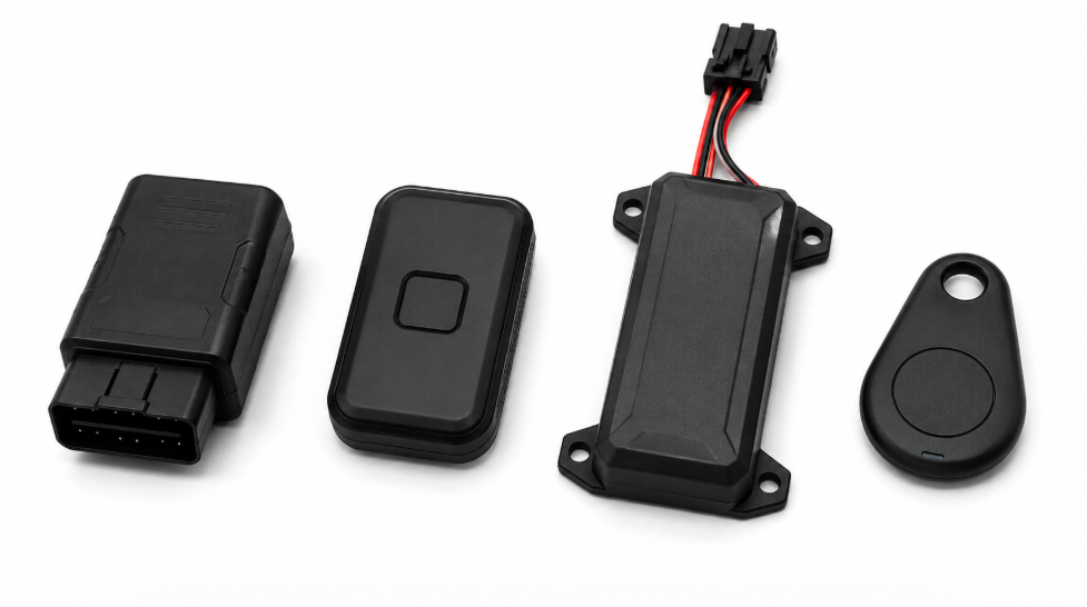
Types of GPS Trackers: Which One Is Right for You?
Passive GPS Trackers
Passive trackers store location data internally rather than transmitting it over cellular signals. When you retrieve the GPS tracking device, you download the full route history via USB or Bluetooth. No SIM card, no subscription, no recurring cost.
Because passive trackers don't continuously transmit over cellular networks, battery life is significantly longer, weeks to months on a single charge. GPS data accuracy remains consistently 2-4 meters even in areas with limited network coverage.
Best for: route auditing, mileage logging, insurance documentation, legal investigations, and any use case where reviewing GPS data later is sufficient.
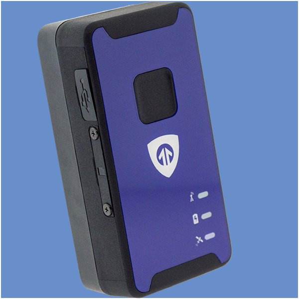
Real-Time GPS Trackers
Active trackers transmit location data continuously over cellular networks, typically 4G LTE. You can watch movement live on a map, receive instant geofencing alerts, and react within seconds. These GPS tracking devices require a monthly data plan but deliver the highest situational awareness for fleet managers, parents, and asset protection teams.
Update intervals range from every 5 seconds to every 5 minutes, depending on the subscription plan and battery mode. High-frequency updates are standard for commercial fleets and vehicle security use cases.
Best for: fleet management, teen driver monitoring, theft recovery, lone worker personal safety, and high-value asset tracking.


Bluetooth Trackers
Bluetooth trackers like Apple AirTag are short-range location devices, they work within roughly 100-200 feet of a paired smartphone rather than using GPS satellites directly. They are designed for keys, bags, and small items rather than vehicle tracking or fleet management. Unlike GPS trackers, Bluetooth trackers do not provide real-time tracking over long distances or send data to a central server independently.
| Tracker Type | Real-Time? | Subscription? | Battery Life | Best Use Case |
|---|---|---|---|---|
| Real-Time / Active | Yes | Required | Days to weeks | Fleet, vehicle security, theft recovery |
| Passive / Data Logger | No | Not needed | Weeks to months | Route audits, legal, mileage logs |
| Hardwired | Yes | Required | Unlimited (vehicle power) | Commercial fleets, permanent install |
| OBD-II Plug-In | Yes | Required | Unlimited (vehicle power) | Personal vehicles, small fleets |
| Battery-Powered Portable | Yes | Required | Days to months (configurable) | Asset trackers, covert monitoring |
| Bluetooth Trackers | No (short-range only) | Not needed | Months to a year | Keys, bags, small personal items |
Key Features of Modern GPS Tracking Technology
Geofencing
Geofencing lets you draw a virtual boundary on a map, a neighborhood, a job site, a school zone. When a GPS tracking device enters or exits that zone, you get an instant alert via SMS or push notification. This is one of the most practical features for parents, fleet managers, and asset management teams alike.
Geofencing alerts users the moment an asset enters or leaves a designated area, giving fleet managers and parents instant awareness without having to watch a live map all day. Combined with real-time GPS tracking, geofencing turns location data into a proactive safety tool.
Speed and Driver Safety Alerts
Most fleet-grade GPS tracking systems log speed, harsh braking, rapid acceleration, and sharp cornering. These driver behavior data points reduce accident risk, lower insurance premiums, and extend vehicle life. Real-time alerts help fleet managers coach drivers before small habits become costly incidents.
Trip History and Route Playback
Every trip is recorded with timestamps, stops, speeds, and durations. You can replay the exact route any vehicle traveled over any date range. This is invaluable for mileage reimbursement, legal disputes, and operational audits, giving logistics companies and fleet managers timestamped proof of where each company vehicle was at any time.
Battery and Power Alerts
Portable GPS trackers notify you when battery life is running low so you never lose visibility at a critical moment. Hardwired trackers alert you if someone severs the connection to the vehicle's electrical system, a common tactic in vehicle theft.
SOS and Panic Buttons
Personal safety and lone worker GPS trackers often include a physical SOS button that instantly sends an alert with the user's exact position to designated contacts or a monitoring center. This feature is particularly valuable for field service workers, elderly family members, and anyone working in remote locations.
Conclusion: GPS Tracking That Works When It Matters
Understanding how GPS trackers work puts you in control of your decision. From the physics of trilateration to the choice between cellular networks and satellite signals, every detail shapes what a GPS tracking device can do for you.
The right GPS tracker for a fleet manager is different from the right one for a parent monitoring a teen driver. The right one for a private investigator is different from one protecting a construction trailer. What every effective GPS tracking system shares: precise satellite positioning, reliable data transmission, and a platform that turns raw GPS data into actionable information.
BrickHouse Security offers GPS tracking devices designed for both personal safety and professional fleet management with real-time tracking, geofencing, driver behavior monitoring, and 24/7 support built in. Whether you are protecting what matters most at home or managing a fleet of 50 commercial vehicles, we have a GPS tracking solution built around your needs.
Frequently Asked Questions
How accurate is a GPS tracker?
Do GPS trackers work without cellular service?
How often do GPS trackers update location?
Can a GPS tracker work indoors?
Is it legal to put a GPS tracker on someone's car?
What is the difference between a GPS tracker and a Bluetooth tracker?
Posted by Todd Morris on Apr 25th 2024